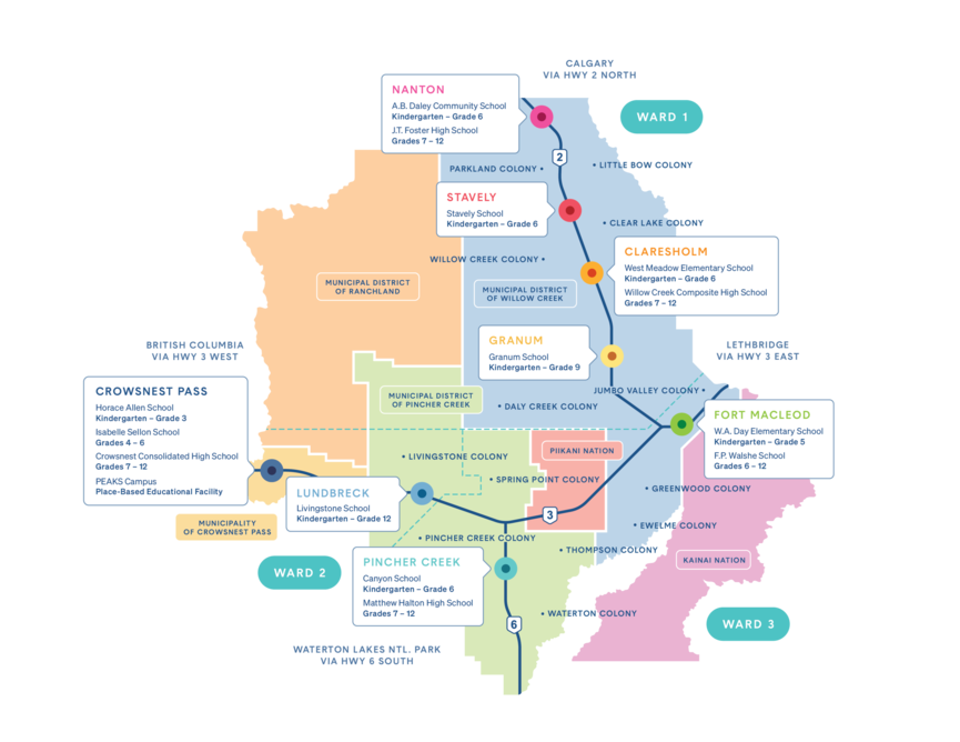
Colonies are listed geographically, starting at the north end of the Division. A map of communities, schools, and colony locations is at the bottom of the page.
Directions
Parkland Colony: NE 2-15-28 W4
North on Highway 2 from Claresholm. Turn west (left) on Secondary Highway # 529 (Twp.Rd.150) between Stavely and Parkland, cross the old highway, 2a and go straight west for 5.8km. to Rge. Rd. 281. Turn north (right) and go .8km. to colony gate on left.
From Nanton, go south on Rge. Rd. 282 from where it joins with Secondary Highway 533 near Nanton cemetary for 10 km. to Twp.Rd. 152. Turn east (left) and go 1.6km. to Rge.Rd. 281. Turn south (right) and go 2.4km. to colony gate on right.
Little Bow Colony: NW 31-14-24 W4
North on Highway 2 from Claresholm. Turn east (right) on Secondary Highway # 529 (Twp.Rd.150) between Stavely and Parkland, go straight east for 19.6 km just past the valley of Little Bow River to Twp. Rd. 150A .Turn east (right) and go 2.7km.to the colony gate on the right.
To cut across from Little Bow to Clear Lake use Rge.Rd. 260 which joins Secondary Highway 529 and Stavely paved road Twp.Rd. 142.
Willow Creek Colony: SE 20-13-27 W4
North on Highway 2 from Claresholm to Twp. Rd. 132. Turn west (left) and go 2.4km. to Rge.Rd. 274. Turn right and go 1.9 km. to colony gate on left. From Stavely, go south on Highway 2 to Twp. Rd. 134 and go 1.5km. west to Rge.Rd.274. Turn left and go 1.4km. south to colony gate.
Clear Lake Colony: NE 22-13-25 W4
North of Central Office gate on Rge. Rd. 271 for 8.8km. to Twp. Rd. 134. Turn east (right) and go 18.8km. to Rge. Rd. 252. Turn north (left) and go 1.3km. Colony gate on left. From Stavely go 23.6 km. straight east on Twp. Rd. 142 to Rge. Rd. 252. Turn South (right) and go 5.2km. to colony gate on right.
Daly Creek (Granum) Colony: SE 28-10-27 W4
From Highway 2 at Granum go west on Twp Rd. 110 3.1 km. to Rge. Rd.272. Turn south (left) and go 3.3km. to Twp. RD. 104. Turn west (right) and go 2.4km. to colony gate on the right.
Jumbo Valley Colony: Legal Land Description to come.
From Granum, on Highway 519 travel eastward 11.9 km, until you reach Range Road 254. Then, turn south and travel 2.3 kilometres and you will arrive at this new colony.
Spring Point Colony: SW 36-8-29 W4
From Highway 2 at Buffalo Jump corner at Fort Macleod turn west (right) and follow Secondary Highway 785. Go past Buffalo Jump and at 18.7km. pavement ends but continue on good gravel road to the 32.6 km. mark on your odometer. The colony gate is on your right.
From Pincher Creek, proceed to junction of Highway 3 and Secondary 785, at the egg beater wind project. Go north on Secondary 785, good paved road, and continue on Twp.Rd. 74, a rough oiled road 13.5 km. to Rge.Rd. 29-0. Turn north (left) and continue on Rge.Rd. 29-0 for 11.5 km. To colony gate on left.
Greenwood Colony: NE 15-7-25 W4
From the junction of Highway 3 and Highway 2, just south of Fort Macleod, go 12.6 km. south on Highway 2 to Twp.Rd. 80. Turn left and go 4 km. east to a T intersection, turn right onto Rge.Rd. 252 and go 2.5 km. south to colony gate on left.
Check below to get from Greenwood Colony to Ewelme Colony.
Greenwood to Ewelme:
To get from Greenwood colony to Ewelme across country, go south from colony gate 4 km. to Twp.Rd. 72. Turn right and go west 3.3 km. to Highway 2. Cross Highway 2, staying on Twp.Rd. 72, continuing on west another 8.2 km. to Secondary Highway 810. Turn left and go south 14.4 km. to Ewelme gate on left.
Ewelme Colony: SW 7-6-26 W4
Go west of Fort Macleod overpass to Secondary Highway 810. Turn left onto 810 ( paved road ) and go 31.5 km. to colony gate on left.
Thompson Colony: NW 30-5-27 W4
Continue on from Ewelme's gate 1.6 km. south on Secondary Highway 81,0 to Secondary Highway 507 ( also paved ). Turn right and go 5.3 km. west to colony gate on left.
From Pincher Creek:
At the Co-op shopping center, east of Pincher Creek, turn right onto paved Secondary 507. Travel 32.9 km. on 507 to colony gate on right.
Livingstone Colony: NW 14-7-2 W5
From junction of Highways 3 and 22, west of Lundbreck, go north 6.2 km. on Highway 22 to colony sign on right. Turn right onto Twp.Rd. 8-2 and follow gravel road 2.7 km. to colony gate on left.
Pincher Creek Colony: SE 28-6-30 W4
From intersection of Highway 6 and Secondary Highway 507, at the A & W in Pincher Creek, go 1.1 km. west on 507 to colony sign on right. Turn right onto Twp.Rd. 6-4 and go 2.2 km. to colony gate on right.
From Cowley:
At Cowley, turn right onto South Fork Road, and travel 7.5 km. on oiled road to Rge. Rd. 1-1. Turn right and go 3.3 km. to Twp. Rd. 6-4. Turn left. and go 2.3 km. on Twp. Rd. 6-4 to colony gate on left. Sign at gate is Rge. Rd. 30-4.
Waterton Colony: SE 3-4-28 W4
From Heritage Inn on Highway 6 in Pincher Creek, go 27.9 km. south on Highway 6 to Twp.Rd. 4-0, just past Twin Butte. Turn left onto Twp.Rd. 4-0 and go 13 km. east to colony gate at left.
Waterton Colony From Ewelme Colony:
Go South from Ewelme Colony 11.3 km. on Sec. Hwy. 810 to a T intersection joining Sec. Hwy. 505. Turn right and go 11.1 to Sec. Hwy. 800 at the Hillspring sign. Turn left. Go through Hillspring to a T intersection. Turn left then turn right onto Sec. Hwy. 800 again. Go south 3.3 km. to Twp.Rd. 4-0 and Waterton Colony sign. Turn right and go west 5.5 km. to colony gate on right.


